


Ancient%20Monuments
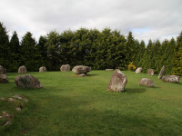
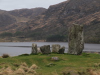
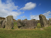
Kenmare Stone Circle
Southwest Ireland | County Kerry
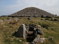
Kenmare Stone Circle, locally known as Shrubberies, is located just a few minutes walk from the center of Kenmare Town in County Kerry. It is considered to be the largest stone circle in the southwest of Ireland. It has an oval shape of a diameter of 17m at the widest point and 15m at the narrowest. It consists of 15 large stones with a large boulder burial ... more info and photos
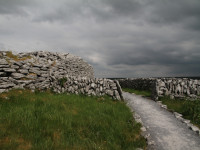
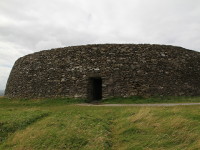
Caherconnel Stone Fort
West Ireland | County Clare
Caherconnell is a very well-preserved stone ring fort located in the Burren region in County Clare. It is a dry-stone structure with a diameter of 40 m, which makes it one of the largest ring forts in Ireland. The walls are up to 3 m high but in its heydays had a height of 4 m. These impressive proportions suggest that it was built and occupied by a very imp... more info and photos
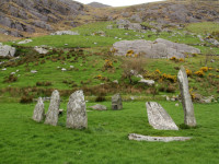
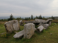
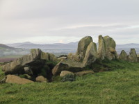
Shronebirrane Stone Circle
Southwest Ireland | County Kerry
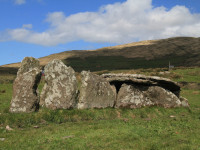
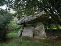
Shronebirrane Stone Circle is located in the valley of the Drimminboy River, about 4km southeast from Lauragh, on Beara Peninsula, in County Kerry. This recumbent multiple-stone circle has a diameter of 7,5 meters and had 13 stones of which 8 remained. The tallest, north-east portal stone dominates the ring and is about 2.6 meters. The height of the stones d... more info and photos
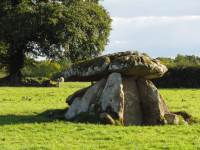
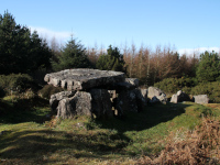
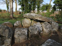
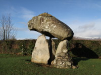
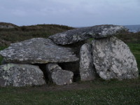
Haroldstown Dolmen
Southeast Ireland | County Carlow
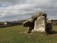
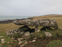
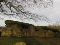
Haroldstown Dolmen is situated on the banks of the Derren River about 8 km northeast from Tullow in County Carlow, just off the road R727 beside the Acaun Bridge. It is a very well preserved portal tomb which dates back to the Neolithic period (4200 - 2400 BC). It consists of two slightly tilted granite capstones supported on ten large upright stones, two of... more info and photos
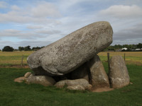
Brownshill Portal Tomb
Southeast Ireland | County Carlow
Brownshill Portal Tomb, also known as Kernanstown Cromlech is located a few kilometres east from Carlow town, just off the road R726. This megalithic monument is circa 5000 years old and is reputed for having one of the heaviest capstones of all European dolmens. Approximate weight of this massive granite capstone is 100 tons and measures around 6 by 5 metre... more info and photos
Athgreany Stone Circle
East Ireland | County Wicklow
Athgreany Stone Circle (also known as Piper's Stones) is located at Athgreany townland, just off the road N81, in County Wicklow (about 2,5 km south from Hollywood). This Bronze Age stone circle has a diameter of 23 meters and consists of 14 granite boulders, the tallest of which is 1.8 meters. Originally there were much more stones, which probably were bro... more info and photos
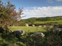
The Cavan Burren
Midlands Ireland | County Cavan
The Cavan Burren is a group of megalithic monuments situated on limestone plateau about 4km south of Blacklion (part of Marble Arch Caves UNESCO Global Geopark), in the northwest corner of Co. Cavan. The prehistoric complex consists of the monuments dating back to Stone Age, Bronze Age and Early Medieval times. There are two portal tombs: Burren Portal Tomb ... more info and photos
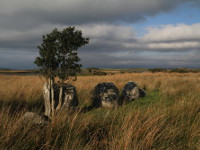
Shantemon Stone Row
Midlands Ireland | County Cavan
Shantemon Stone Row is situated in the middle of a conifer plantation on the northern slope of Shantemon Hill in County Cavan. It is also known as "Finn McCool’s Fingers", and legend says that these stones are fingers of a legendary giant warrior. The alignment is 16 m long, is lined up along a NE-SW axis and consists of five boulders graded in height from 0... more info and photos
Coom Wedge Tomb
Southwest Ireland | County Kerry
Coom Wedge Tomb is situated just of the scenic road Skellig Ring, about 3 km east of Ballinskelligs, on Iveragh Peninsula in County Kerry. It dates from the time between the late Stone Age and the early Bronze Age. Excavations were carried out in 1965-66 and only a short flint flake was found under the remains of the cairn. No traces of burials or grave good... more info and photos
Drumanone Portal Tomb
Midlands Ireland | County Roscommon
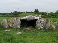
Drumanone Portal Tomb is located nearby Sligo-Dublin railway line, about 3 km west of Boyle in County Roscommon, on the east end of Lower Lough Gara. This very well preserved Neolithic monument was excavated in 1954 and during the research, several cremations were found as well as a porcellanite axe-head which archaeologists believe came from axe quarry at t... more info and photos
The Labby Rock
Northwest Ireland | County Sligo
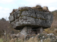
The Labby Rock also called Carrickglass Portal Tomb is located on the northeastern end of Lough Arrow in County Sligo, just behind the Cromlech Lodge hotel. This dolmen was built in Neolithic times and is one of the biggest in Ireland, with a capstone weighing approximately 65 tons and dimensions about 5 x 3 x 1.5 meters. It rests on four orthostats of which... more info and photos
Carrowcrom Wedge Tomb
West Ireland | County Mayo
Carrowcrom Wedge Tomb is located 9 km southeast of Ballina town in County Mayo. This well preserved megalithic monument dates back to c.2500 - 2000 BC. The gallery is about 3.5m long with the entrance of 1.5m wide flanked of each side by a short facade consisting of four large orthostats with drywalling between them. It is covered by single, 2m long capstone... more info and photos
Darby's Bed
West Ireland | County Limerick
Darby's Bed, also known as Duntryleague Passage Tomb is located near the village of Galbally in southeast County Limerick. The remains of this megalithic monument probably date to around 3000 BC. It's a rare example of passage tomb in this part of Ireland. Its roofstones rise like steps to the top of the chamber, what suggesting influences from Brittany. It ... more info and photos
Ceide Fields
West Ireland | County Mayo
Céide Fields are located about 7 kilometers northwest of Ballycastle in County Mayo. It is one of the most important archaeological sites in Ireland and consists one of the oldest known field systems in the world, over five and a half thousand years old. The remains of stone field walls from Neolithic, were discovered during peat cutting works, by local scho... more info and photos
Doonfeeny Standing Stone
West Ireland | County Mayo
Doonfeeny Standing Stone is located on the old graveyard, 3km northwest of Ballycastle in County Mayo, not far from well known ancient site of Ceide Fields, just of the road R314. This megalithic monument is standing here maybe even from the times of Bronze Age, majestically overlooking the Downpatrick Head and its Dun Briste sea stack. Doonfeeny Standing St... more info and photos
Proleek Wedge Tomb
East Ireland | County Louth
Proleek Wedge Tomb is located about 4km northeast of Dundalk (Co Louth), on a golf course in the grounds of Ballymascanlon Hotel. This megalithic monument was built in Bronze Age period and is locally known as Giant's Grave. Local folklore connects it with nearby Proleek Dolmen and according to this legend the Giant's Grave is a burial place of Scottish gian... more info and photos
Proleek Dolmen
East Ireland | County Louth
Proleek Dolmen is located about 4km northeast of Dundalk (Co Louth), on a golf course in the grounds of Ballymascanlon Hotel. This megalithic monument was built in early Neolithic period, around 3000 BC. It consists of two massive, over 2m high portal stones and back stone, which support hudge capstone, weighing approximately 40 tons. Back stone has concret... more info and photos
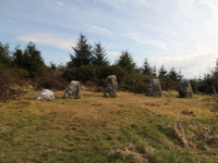
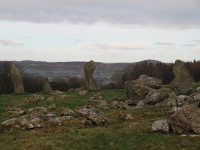
Dereenataggart Stone Circle
Southwest Ireland | County Cork
Derreenataggart Stone Circle is located near Castletownbere, on Beara Peninsula, in west part of county Cork. This well preserved example of a recumbent stone circle has 7.8m in diameter and probably had 15 upright stones of which 9 are still standing, 3 have fallen and 3 are missing. The entrance is marked by pair of tallest stones (the portal stones) and t... more info and photos
Rathgall Hillfort
East Ireland | County Wicklow
Rathgall Hillfort, one of the largest in Ireland, is situated on rounded hill in south west part of County Wicklow (about 6 km east of Tullow, Co Carlow). It includes four concentric ramparts, the three outer ones made of stone and earth dating from the Late Bronze Age, around the 1000BC. The inner, dry stone walled ring fort was added in Early Christian tim... more info and photos
Seefin Passage Tomb
East Ireland | County Wicklow
The Seefin Passage Tomb is situated on the top of a 650 meters high mountain in north part of County Wicklow and is not the only one in this area. Two other cairns are visible on the nearby peaks. This kind of megalithic structures dates back to Neolithic Period, so it's over 5000 years old. The monument has approx 25 m in diameter and is 3 m high. The entr... more info and photos
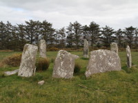
Uragh Stone Circle
Southwest Ireland | County Kerry
Uragh Stone Circle is located near Gleninchaquin Park, on Beara Peninsula, County Kerry (around 15km southwest from Kenmare, signposted on the road R571). It has stunning location on the low hill between lakes Cloonee Upper and Lough Inchiquinn, with the waterfall on the background. The stone circle is 2.4 m (8 feet) in diameter and consists of five upright... more info and photos
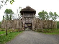
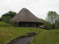
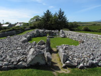
Irish National Heritage Park
Southeast Ireland | County Wexford
The Irish National Heritage Park is an open air museum located on the picturesque banks of the River Slaney on the outskirts of Wexford (just off N11). The park, situated on 35 acres of natural woodlands and wetlands takes you on the journey through the Ireland's ancient past, which starts 9000 years ago when first people (hunters-gatherers) appeard in Irela... more info and photos
Cleggan Court Tomb
West Ireland | County Galway
Cleggan Court Tomb is situated on the northern shore of Cleggan Bay (County Galway) within a few meters of a low cliff which rises about 9m above the sea level. The monument is aligned ESE-WNW, with the entrance towards east. The gallery contains three separated chambers, of which only the middle one retains a large roofstone (3m long, 1.7m wide and up to 0.... more info and photos
Kilmogue Dolmen
Southeast Ireland | County Kilkenny
Kilmogue Dolmen (or Harristown Dolmen) is located about 7 km north-east of Mullinavat Town in County Kilkenny (short distance off M9 motorway). It is also known as "Leac an Scail" what means "the stone of the hero". The exact date of construction is unknown, but dates back at least to 3000 BC. It's made of granite, and its portal stones are around 3.7m high... more info and photos
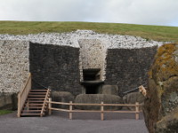
Newgrange
East Ireland | County Meath
The passage tomb of Newgrange is one of the most important Neolithic Monuments in Europe and toghether with Knowth and Dowth, has been designated as UNESCO World Heritage Site, what makes it one of the most visited tourist attractions in Ireland. It is located about 4 km east of the village of Slane, in County Meath (the only access to the monument is throug... more info and photos
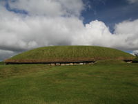
Knowth
East Ireland | County Meath
Knowth Passage Tomb is one of the most important Neolithic Monuments in Europe and toghether with Newgrange and Dowth, has been designated as UNESCO World Heritage Site, what makes it one of the top tourist attractions in Ireland. It is located about 4 km east of the village of Slane, in County Meath (the only access to the monument is through the Bru na Boi... more info and photos
Ballyganner South Wedge Tomb
West Ireland | County Clare
Ballyganner South Wedge Tomb, located about 4 km east from Kilfenora in County Clare has the largest chamber of all the wedge tombs of Burrren.The monument decreases regularly in height and width from west to east and its sides are each made of one huge slab. Its chamber is 4.20m long, 2.95m wide and 1.60m high at the west, and 2m wide and 1m high at the e... more info and photos
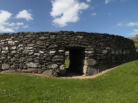
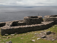
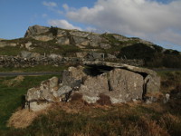
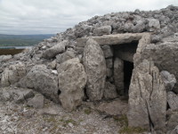
Loher Stone Fort
Southwest Ireland | County Kerry
Loher Stone Fort is situated on the foothills of Beenarourke and Farraniaragh Mountain, overlooking Ballinskelligs Bay, midway between towns of Caherdaniel and Waterville, on the Iveragh Peninsula in County Kerry (visible on the "Ring of Kerry" scenic coastal road). This drystone walled ring fort, which was really a defensive farmstead of local chieftain, w... more info and photos
Knockbrack
West Ireland | County Galway
Knockbrack, also known as Labbadermot is a megalithic monument situated on the seashore on the western side of Sallerna Bay, about 1.5 km west from fishing village of Cleggan, County Galway. The classification of this megalith leaves some doubt but the interpretation as a wedge tomb is the most likely. It's also hard to define the date of its construction b... more info and photos
Lough Gur
West Ireland | County Limerick
Lough Gur is small, horseshoe shaped lake wrapped around Knockadoon Hill, situated about 20 km south east of Limerick City (just off the road R512). It is one of the most important archaeological sites in Ireland with rich finds and evidence of continuous human habitation over the last 6000 years. The reason why people have settled right here was fertile soi... more info and photos
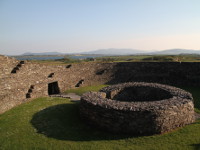
Caher Conor
Southwest Ireland | County Kerry
Caher Conor (Cathair na gConchuireach, also known as the Fahan Beehive Huts) is located on the southern slope of Mount Eagle, to the west of Ventry, on Dingle Peninsula, County Kerry (road R599, not far from Dunbeg Promontory Fort). This enclosed farmstead contains five clochans (beehive huts) within its walls and was probably inhabited by single family. Su... more info and photos
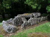
Labbacallee Wedge Tomb
Southwest Ireland | County Cork
Labbacallee Wedge Tomb is located 2 km southeast of Glanworth, County Cork (8 km north-west of Fermoy). Its name comes from Irish words "leaba caillighe", which means "the bed of the hag/witch". The monument dates from the early Bronze Age and it is the largest wedge tomb in Ireland. The gallery is 7.75 m long, divided on two chambers (6.2 m and 0.9 m long)... more info and photos
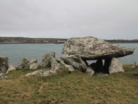
Gaulstown Portal Tomb
Southeast Ireland | County Waterford
The dolmen located in Gaulstown, about 8 km southwest of Waterford is one the finest portal tombs in Ireland. Megalith is situated in small woodland at the foot of hillside locally known as "Hill of the Hag" and dates from around 3500 BC. The huge rectangular capstone of dimensions approx 4m by 2.5m (1m thick) and weight about 6 tons rests on 5 upright stone... more info and photos
Srahwee Wedge Tomb
West Ireland | County Mayo
Srahwee, locally known as "Altóir" (altar) is well-preserved example of wedge tomb located about 10km south from Louisburgh in County Mayo. This megalithic monument was build in the Bronze Age about 2000 BC. The tomb has double walls and is covered by a large flat stone of dimension 2.4m by 2.15m. In 18th century the tomb was used as an altar by priests who ... more info and photos
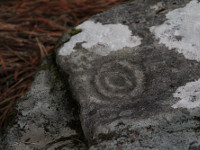
The Boheh Stone
West Ireland | County Mayo
The Boheh Stone, also known as St Patrick’s Chair is one of the finest examples of neolithic rock art in Ireland, located behind abandoned house approx 300 m of road N59, 8km south from Westport in County Mayo (is signposted as "Site 2" of Clew bay Archaeological Trail). The monument itself is a large rock about 2m tall with over 250 individual petroglyphs c... more info and photos
Killadangan Megalithic Complex
West Ireland | County Mayo
The megalithic complex of Killadangan is situated on the southern shore of Clew Bay, about 5km west of Westport and 2km east of Murrisk (road R335) and is part of Clew Bay Archaeological Trail. The monuments, probably date from the Bronze Age and consist a Stone Row, a Stone Pair, four Standing Stones and possible remains of a fulacht fiadh (bronze-age cooki... more info and photos
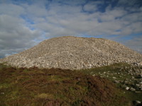
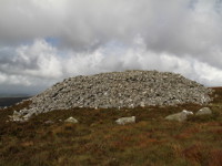
Queen Maeves Grave
Northwest Ireland | County Sligo
Queen Maeve's Grave (irish: Miosgán Meadhbha) is large passage tomb situated on the top of Knocknarea Mountain (327m), dominating the landscape of the Coolera peninsula in County Sligo. Legend says, that is the final resting place of Queen Maeve of Connacht, the ancient warrior queen. This Neolithic monument has approx 55 m in diameter, is 11 m high and w... more info and photos
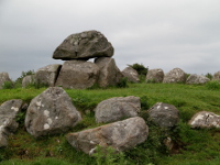
Carrowmore Megalithic Cemetery
Northwest Ireland | County Sligo
Carrowmore Megalithic Cemetery is situated in the center of The Coolera Peninsula (irish:Cuíl Irra) around 6 km southwest from Sligo Town in County Sligo. It's one of the largest and oldest megalithic complex in Europe, where some of the tombs have been erected 4000 BC. There are around 30 stone structures still visible on the site, but there were many more ... more info and photos
Creevykeel Court Tomb
Northwest Ireland | County Sligo
Creevykeel Court Tomb is the one of the finest court tombs in Ireland. Is located off N15 in village of Cliffony in north County Sligo (between the village of Grange and town of Bundoran). This type of megalithic structures began to appear shortly after 4000 BC. In its present form it is termed a full court tomb but there is evidence that it was once a simpl... more info and photos
Deerpark Court Tomb
Northwest Ireland | County Sligo
Deerpark Court Tomb, also known as Magheraghanrush, is located in small forest park, just off the road no R278 about 1 km east of the village of Calry in County Sligo (8 km east from Sligo Town). This fine example of a central court tomb was built around 3000 BC. There is a hypothesis that it was once a simpler construction with open, U - shaped forecourt. T... more info and photos
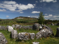
Carrowkeel Passage Tomb Cemetery
Northwest Ireland | County Sligo
Carrowkeel Passage Tomb Cemetery are group of Neolithic monuments (built before 3200 B.C and continued to be used for burial rituals into the Bronze Age), spectacularly situated on the tops of Bricklieve Mountains in County Sligo (30 km southeast of Sligo Town). Traveling through N4 in Dublin direction, take a right turn in the village of Castlebaldwin (s... more info and photos
Lough Gur Wedge Tomb
West Ireland | County Limerick
Lough Gur Wedge Tomb (also known as Giant's Grave) is located just 1 km off the road R 512 (Limerick-Kilmallock), near village of Holycross in County Limerick (in Holycross take the left turn onto the road signposted to Lough Gur, just after the pub). After about a 1 km you will see the grave on your right hand side.
This is well preserved, large... more info and photos
Grange Stone Circle
West Ireland | County Limerick
Grange Stone Circle (also known as The Lios) is located beside the road R 512 (Limerick-Kilmallock), 4 km north of Bruff in county Limerick. It is largest stone circle in Ireland, which consists of 113 stones and has 46 m in diameter. It's surrounded by wide earthen, flat-topped bank, about 1.2m tall. There is narrow, stone-lined entrance on the north ea... more info and photos
Ballyedmonduff Wedge Tomb
East Ireland | County Dublin
Ballyedmonduff Wedge Tomb is located on the south eastern slope of Two Rock Mountain in County Dublin, just 18 km from Dublin City Center (beside Glencullen Golf Club). This early Bronze Age wedge tomb is also known as "Giants Grave" and was discovered by Alderman Blacker around 1830. Tomb was excavated in 1945, but unfortunately, by this time, the main c... more info and photos
The Loughcrew Passage Tombs
East Ireland | County Meath
Loughcrew Passage Tombs also known as Sliabh na Caillí (Hill of the Witch) are complex of megalithic monuments located about 4km south east from town of Oldcastle in County Meath. This ancient burial grounds, dating between 3500 BC and 3300 BC are spread over few hills. "Cairn L", "Cairn D" and some smaller cairns are situated on the hill of Carnbane West... more info and photos
Bocan Stone Circle
Northwest Ireland | County Donegal
Bocan Stone Circle is located on Inishowen Peninsula in County Donegal, approx 2 km from Culdaff Village towards Moville - road R238 (take the first left turn after St Mary's Church in Bocan, and after around 100m you will see it through the field gate on your left side). The stone circle was built between 3000 BC and 1500 BC and had around 30 standing sto... more info and photos
Temple of Deen
Northwest Ireland | County Donegal
Temple of Deen, also known as Druids Altar is the remains of court tomb located approx 2 km from Culdaff Village (towards Moville), on Inishowen Peninsula in County Donegal. It stands on the top of small hill (known as "Black Hill"), on the right hand side of the road, and you can get there on the foot using a dirt road. The exact date of construction is unk... more info and photos
Beltany Stone Circle
Northwest Ireland | County Donegal
Beltany Stone Circle is located approx 3 km south from Raphoe Town, in east part of County Donegal (just beside Department of Agriculture, Food and the Marine, Tops Potato Centre). This megalithic monument probably was built in the later Bronze Age, about 1400 to 800 BC as important centre of ritual practise. The arrangement of stones may also suggest it was... more info and photos
Staigue Fort
Southwest Ireland | County Kerry
Staigue Fort (An Stéig) is partly ruined (but one of the largest and finest in Ireland) dry-stone, walled ringfort, located on the Iveragh peninsula in County Kerry (Ring of Kerry). Probably built in the early centuries AD as defensive stronghold for local chieftain. Fort is surrounded by earthen bank and ditch, has about 27 m (90 ft) in diameter, its wa... more info and photos
Dunbeg Promontory Fort
Southwest Ireland | County Kerry
Dunbeg Fort (Dún Beag) is located on craggy promontory between Ventry and Slea Head (road R599) on Dingle Peninsula in County Kerry. Remains that have survived to this days were built between the 8th and 10th century, but excavations have shown some evidence of human residence dating from 8th century BC. There is no evidence that Dunbeg was ever again occu... more info and photos
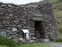
Leacanabuaile Stone Fort
Southwest Ireland | County Kerry
Leacanabuaile Stone Fort is located near Cahersiveen in Ballycarbery East on Iveragh Peninsula in County Kerry. Partly reconstructed but still under construction dry-stone walled fort is one of very few in Ireland of these to be excavated (in 1939/40). Objects found there dating from 8th and 9th century and suggesting the existence of an early Christian f... more info and photos
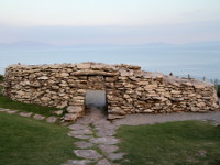
Cahergall Stone Fort
Southwest Ireland | County Kerry
Cahergall Stone Fort is located near Cahersiveen in Ballycarbery East on Iveragh Peninsula in County Kerry. The name Cahergall comes from the Gaelic words, Chathair Gheal, which mean “The Bright Fort”. Recently renovated dry-stone walled ring fort probably dates from late Iron Age or early Medival period. It has about 25 meters in diameter, walls are up to 4... more info and photos
Altar Wedge Tomb
Southwest Ireland | County Cork
Altar Wedge Tomb - built from local slabs, this wedge shaped tomb is one of a dozen in the Mizen peninsula. It was first erected at the end of the Stone Age, around 3,000 to 2,000 BC, with its entrance deliberately lined up with the distant Mizen Peak. Archaeologists recently uncovered some burnt human bone which they radiocarbon dates to about 2,000 BC a... more info and photos
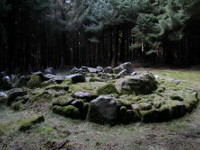
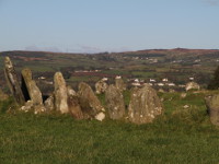
Drombeg Stone Circle and Fulacht Fiadh
Southwest Ireland | County Cork
Drombeg is a fine example of a recumbent stone circle located about 2.5 km east of Glandore, in west County Cork. It has about 9 m in diameter and consists of 17 stones of which 13 are original. The entrance, situated from the north-east side is marked by pair of tallest stones (the portal stones) and together with recumbent stone, which is placed opposite, ... more info and photos
Grianan of Aileach
Northwest Ireland | County Donegal
Grianan of Aileach (irish: Grianán Ailigh) is dry-stone walled ring fort, located on a hilltop over Lough Foyle and Lough Swilly, in county Donegal. It was probably built in the 8th century as the royal citadel of the northern Uí Néill, on the site of prehistoric burial mound, possibly from the Neolithic period (about 3000 BC). Ring fort rises to high of... more info and photos
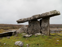
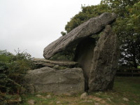
Poulnabrone Dolmen
West Ireland | County Clare
Poulnabrone is a classic example of a portal tomb and probably one of the most famous megaliths in Ireland. It is situated on the Burren's limestone pavement just beside road R480 (more or less in half way between Ballyvaughan and Leamaneh). Monument stands in a low circular mound of loose stones, measuring about 10m in diameter. The entrance to a rectangula... more info and photos