


County Mayo
County Mayo is the third-largest of Ireland's counties and is located on the west coast. The peat bogs and smooth hills create a landscape of its northern part, sandy beaches, cliffs, rugged headlands and islands, that's south which is also more agricultural. The major attractions in County Mayo are with no doubt: National Museum of Ireland - Country Life, Knock Shrine and Croagh Patrick Mountain with their countless pilgrims, the wonderful landscapes of Achill Island with its highest sea cliffs in Ireland and The Kildavnet Castle - home of Irish pirate queen Grace O'Malley. Worthy of interest are also Rockfleet Castle (also linked with Grace O'Malley), the ruins of the Burrishoole Friary or Turlough Round Tower - one of the earliest round towers in Ireland. Anglers regard Mayo as on of the best fishing places in Ireland.
Interesting places in county Mayo
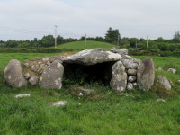
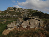
Carrowcrom Wedge Tomb
West Ireland | County Mayo
Carrowcrom Wedge Tomb is located 9 km southeast of Ballina town in County Mayo. This well preserved megalithic monument dates back to c.2500 - 2000 BC. The gallery is about 3.5m long with the entrance of 1.5m wide flanked of each side by a short facade consisting of four large orthostats with drywalling between them. It is covered by single, 2m long capstone... more info and photos
Ceide Fields
West Ireland | County Mayo
Céide Fields are located about 7 kilometers northwest of Ballycastle in County Mayo. It is one of the most important archaeological sites in Ireland and consists one of the oldest known field systems in the world, over five and a half thousand years old. The remains of stone field walls from Neolithic, were discovered during peat cutting works, by local scho... more info and photos
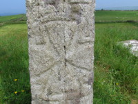
Doonfeeny Standing Stone
West Ireland | County Mayo
Doonfeeny Standing Stone is located on the old graveyard, 3km northwest of Ballycastle in County Mayo, not far from well known ancient site of Ceide Fields, just of the road R314. This megalithic monument is standing here maybe even from the times of Bronze Age, majestically overlooking the Downpatrick Head and its Dun Briste sea stack. Doonfeeny Standing St... more info and photos
Belleek Castle
West Ireland | County Mayo
Belleek Castle is located on the outskirts of the town of Ballina in County Mayo (about 2 km north of town center). It was built by Sir Arthur Francis Knox-Gore (designed by Irish architect John B.Keanes), between 1825 and 1831, on the site of a medieval abbey, one of four along the River Moy. The Knox-Gore family lived in Belleek Castle until 1940's, when t... more info and photos
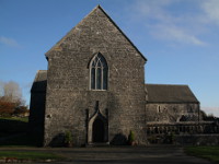
Ballintubber Abbey
West Ireland | County Mayo
Ballintubber Abbey (Tobar Padraic) is located 12 km south of Castlebar, near the village of Ballintubber (2km off road N84) in County Mayo. It was founded in 1216 by King of Connacht, Cathal O’Conor (Cathal Crobhdearg Ua Conchobair) and is known as the Ireland’s only royal abbey that has been in continuous use until today. Even in the time of dissolution of ... more info and photos
Srahwee Wedge Tomb
West Ireland | County Mayo
Srahwee, locally known as "Altóir" (altar) is well-preserved example of wedge tomb located about 10km south from Louisburgh in County Mayo. This megalithic monument was build in the Bronze Age about 2000 BC. The tomb has double walls and is covered by a large flat stone of dimension 2.4m by 2.15m. In 18th century the tomb was used as an altar by priests who ... more info and photos
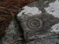
The Boheh Stone
West Ireland | County Mayo
The Boheh Stone, also known as St Patrick’s Chair is one of the finest examples of neolithic rock art in Ireland, located behind abandoned house approx 300 m of road N59, 8km south from Westport in County Mayo (is signposted as "Site 2" of Clew bay Archaeological Trail). The monument itself is a large rock about 2m tall with over 250 individual petroglyphs c... more info and photos
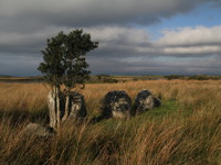
Killadangan Megalithic Complex
West Ireland | County Mayo
The megalithic complex of Killadangan is situated on the southern shore of Clew Bay, about 5km west of Westport and 2km east of Murrisk (road R335) and is part of Clew Bay Archaeological Trail. The monuments, probably date from the Bronze Age and consist a Stone Row, a Stone Pair, four Standing Stones and possible remains of a fulacht fiadh (bronze-age cooki... more info and photos
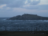
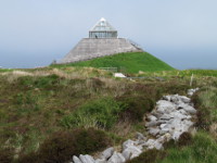
Eagle Island Lighthouse
West Ireland | County Mayo
Eagle Island Lighthouse is located on a small island approximately 1 km of the northwest part of the Mullet Peninsula, in County Mayo.This island is situated close to the edge of the Continental Shelf where the waves of the Atlantic can be extremely high, and the dramatic story of the lighthouse is strictly linked with them. On the night of 29th September 1... more info and photos
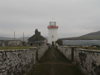
Ballyglass Lighthouse
West Ireland | County Mayo
Ballyglass Lighthouse (also known as Broadhaven Lighthouse) is located on the north eastern tip of the Mullet Peninsula in County Mayo overlooking Broadhaven Bay. The 15 m tall tower was erected in 1848, but the light was first established on 1st June 1855. The light came from oil lamp with fixed third order dioptric (supplied by W. Wilkins of London), was ... more info and photos
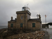
Blacksod Lighthouse
West Ireland | County Mayo
Blacksod Lighthouse is situated on the south east corner of the Mullet Peninsula in county Mayo. This lighthouse as a building is quite unusual. It is two storey massive house (made in 1864/65 of local reddish grey granite), with the white, small square lighthouse tower centered on the top. The first light was established in 30th June 1866 (showing fixed... more info and photos
Mullet Peninsula
West Ireland | County Mayo
Mullet Peninsula is located in northwest part of County Mayo. You will get in there using the road R313 to Belmullet Town leading through narrow stripe of land which separates the Blacksod Bay (on the seabed of Blacksod Bay rests wreck of large Spanish galleon "La Rata Santa Maria Encoronada " which sank in 1588) and the Broad Haven Bay and connects the peni... more info and photos
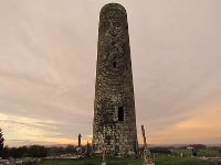
Meelick Round Tower
West Ireland | County Mayo
Meelick Round Tower is located about 6 km southwest from Swinford in County Mayo (on a side road just next to the N5). It was built probably at some time between 923 and 1013 AD and is the only preserved structure of the St. Broccaidh's monastery which was here. The tower is about 21m high, its diameter is close to 5.5 m and the doorway is placed 3,5 m above... more info and photos
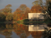
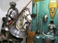
National Museum of Ireland - Country Life
West Ireland | County Mayo
National Museum of Ireland – Country Life is located in Turlough near Castlebar in County Mayo. The modern building situated at the lake on grounds of Turlough Park House is integrated into the unique landscape of surrounding gardens and park. The museum has an impressive collection of items, artefacts and pictures which help to understand the way and the tr... more info and photos
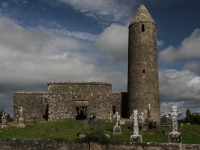
Turlough Round Tower
West Ireland | County Mayo
Turlough Round Tower is located around 7 km northeast of Castlebar on the north side of the N5 just outside of Turlough Village in County Mayo (near the National Museum of Folk Life). Constructed in 9th century its one of the earliest round towers in Ireland. It is about 23m high and close to 5.5 m diameter what makes the tower look short and squat. It has r... more info and photos
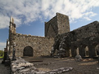
Burrishoole Friary
West Ireland | County Mayo
Burrishoole Friary is the ruin of the Dominican friary dedicated to St Mary, located 2,5km northwest of Newport, in County Mayo. It was founded around 1470 by Richard de Burgo of Turlough, who took the habit under the Dominican Order for the last three years of his life. He built the abbey without pope's permission and the friary was excommunicated until 148... more info and photos
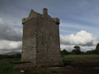
Rockfleet Castle
West Ireland | County Mayo
Rockfleet Castle also known as Carrickahowley Castle (irish: Carraig-an-Cabhlaigh) is fine example of Irish tower house which were built in the likeness of the Norman design. This 16th century stronghold is located approx 7km from Newport in Achill Island direction (road N59), County Mayo. Was built by powerful Clan O’Malley which controlled a large par... more info and photos
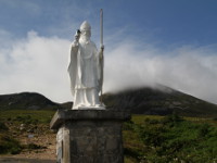
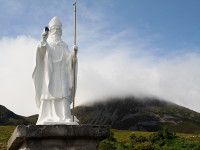
Croagh Patrick
West Ireland | County Mayo
Croagh Patrick is third highest mountain in County Mayo and has 764 m. This is Ireland's Holy Mountain, one of the most sacred and important sites of pilgrimage. The legend said that St. Patrick has fasted and prayed for 40 days here and also said that Croagh Patrick is the mount from which he banished snakes from Ireland forever! There is annual pilgrimage... more info and photos
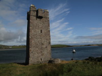
The Kildavnet Castle
West Ireland | County Mayo
The Kildavnet Castle also known as Grace O'Malley's Castle is fine example of Irish tower house which were built in the likeness of the Norman design. This 15th century stronghold is located near small harbour of Kildavnet on the scenic Achill's Atlantic Drive which begins in Achill Sound. Probably built by powerful Clan O’Malley which controlled a large ... more info and photos
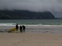
Achill Island
West Ireland | County Mayo
Achill Island is located off the west coast in County Mayo and is the largest island in Ireland (24km x 19km). It is linked to the mainland by Michael Davitt Bridge, between the villages of Achill Sound (Irish: Gob an Choire) and Polranny (Irish: Poll Raithnígh). Jagged coastline, cliffs, mountains, lakes and amazing beaches, it all create unique, fabulous l... more info and photos