


County Clare
County Clare is situated on the west coast of Ireland and it's a land of great natural beauty and wonderful landscapes rich with historical and archaeological sites. The landscape is dominated by differentiated, rugged coast with caverns, mighty cliffs and sandy bays continuously washed by the waves of the Atlantic Ocean and The Burren, the limestone plateau with an area of 250 sq km which is one of the finest examples of a glacio-karst landscape in the world.
With no doubt the most important tourist attraction in the county are famous The Cliffs of Moher - 8km (5 miles) of sea cliffs which are up to 214m (700 feet) high in some point. Travelling along the coast further to the south you encounter the charming harbor towns as Lahinch and Kilkee with beautiful beaches. After Kilkee starts The Loop Head Peninsula, the most westerly part of County Clare , which was announced the “Best Place to Holiday in Ireland” by The Irish Times in 2013. At the end of the peninsula there is well known, still operating Loop Head Lighthouse, which is open for visiting.
Interesting places in county Clare
Caherconnel Stone Fort
West Ireland | County Clare
Caherconnell is a very well-preserved stone ring fort located in the Burren region in County Clare. It is a dry-stone structure with a diameter of 40 m, which makes it one of the largest ring forts in Ireland. The walls are up to 3 m high but in its heydays had a height of 4 m. These impressive proportions suggest that it was built and occupied by a very imp... more info and photos
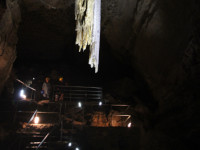
Doolin Cave
West Ireland | County Clare
Doolin Cave, also known as Pol an Ionáin, is located about 4 km northeast of the seaport village of Doolin (road R479) in County Clare, just 12 km from the Cliffs of Moher. This limestone cave was discovered in 1952 by speleology students, J.M. Dickenson and Brian Varley, and became known because of having the longest free-hanging stalactite in Europe. The G... more info and photos
Kilfenora Cathedral and Crosses
West Ireland | County Clare
Kilfenora Cathedral is located on the plateau of Burren in County Clare. It was built in about 1189 on the site of an early monastery founded by St Fachtna in 6th century. The cathedral was simple nave-and-chancel building. The chancel has very well preserved east window of Transitional style and some other noteworthy stonemasons works including 14th-century... more info and photos
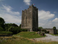
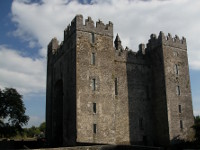
Knappogue Castle
West Ireland | County Clare
Knappogue Castle is a medieval tower house located near Quin, in County Clare. It was built in 1467 by Seán MacNamara and stayed in MacNamara's hands untill 1800 when was sold to Scott family. The new owners have begun extensive modernisation, completed in 1855 by another owner Theobold Fitzwalter Butler, 14th Baron Dunboyne. In that time, the Gothic-revival... more info and photos
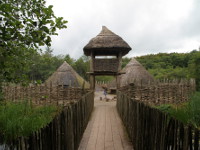
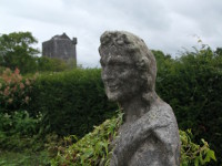
Craggaunowen
West Ireland | County Clare
Craggaunowen is an open air museum located in forest park, 6 km east from Quin (Co Clare), just off road R469 (20 km northwest from Limerick City). This living past experience project was established in 1960's by John Hunt, important historian, antiquarian, and collector (his collections are on display in Hunt Museum in Limerick). The reconstructions, inclu... more info and photos
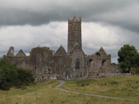
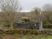
Quin Friary
West Ireland | County Clare
The well preserved friary in Quin, County Clare, was founded around 1402 by MacNamara clan for franciscan friars, and became an Observant Reformed house in 1433. It was established on the ruins of four-towered Norman castle built here by Thomas de Clare around 1280, and destroyed by native Irish clans after winnig battle of Dysert O'Dea in 1318. The remain... more info and photos
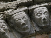
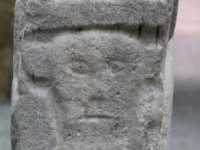
St Tola's Church
West Ireland | County Clare
St Tola's Church, also known as Dysert O'Dea Abbey is located about 4 km south of Corofin town in County Clare, near Dysert O'Dea Castle. The ruins which have survived to this day, date from 12th century and was altered few times throughout its existence, but first monastic settlement was founded here in 8th century by St Tola. The most notable feature of th... more info and photos
Dysert O'Dea Castle
West Ireland | County Clare
Dysert O'Dea Castle is located 5 km south of Corofin in County Clare (signposted on the road R476). This defensive tower house was built between 1470 and 1490 by Diarmuid O'Dea, Lord of Fearmaic. Castle had a turbulent history, changing the owners many times but always was coming back into the possession of the O'Dea clan. In 1651, the stronghold became a C... more info and photos
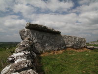
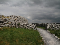
Ballyganner South Wedge Tomb
West Ireland | County Clare
Ballyganner South Wedge Tomb, located about 4 km east from Kilfenora in County Clare has the largest chamber of all the wedge tombs of Burrren.The monument decreases regularly in height and width from west to east and its sides are each made of one huge slab. Its chamber is 4.20m long, 2.95m wide and 1.60m high at the west, and 2m wide and 1m high at the e... more info and photos
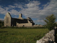
Corcomroe Abbey
West Ireland | County Clare
Corcomroe Abbey, located in the north of the Burren region (aprox 8km east of Ballyvaughan), County Clare, is an early 13th-century Cistercian monastery of which the foundation is attributed either to Donal Mór Ua Briain (Donald O'Brien), or his successor Donough Cairbreach. They were chieftains of the powerful O'Brien clan and the founders of many other rel... more info and photos
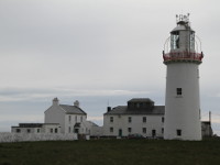
Loop Head Lighthouse
West Ireland | County Clare
Loop Head Lighthouse is situated on a pointed tip of the picturesque Loop Head peninsula, on the south west end of County Clare (its most westerly point). The first lighthouse was established here around 1670, it was stone cottage with lantern placed on the roof. The cottage was home for the keeper and his family and had an internal stone stairway leading... more info and photos
Bunratty Castle and Folk Park
West Ireland | County Clare
Bunratty Castle and Folk Park are located in village of Bunratty (approx. 15 km from Limerick City in Shannon direction) in County Clare. It's one of the most popular and worth visiting tourist attractions in Ireland. Covering an area of 26 acre park includes a medieval castle - Bunratty Castle, 19th century Georgian residence - Bunratty House, 19th cent... more info and photos
/mini/Holy Island (Inis Cealtra).jpg)
Holy Island (Inis Cealtra)
West Ireland | County Clare
Holy Island (Inis Cealtra) is a small inland island located on Lough (lake) Derg, near Mountshannon Village in county Clare. The place is known because of located there ruins of monastic complex. The monastery was founded by St. Colum of Terryglass in 6th century. ln the mid-7th century, St. Caimin built a small church. The settlement was pillaged by the Vik... more info and photos
Temple Cronan
West Ireland | County Clare
Temple Cronan is a small church, sited inside a small walled enclosure located 1.5km north-east from village of Carran, in east part of Burren, County Clare. It was built in the 12th century and in those days, it was monastic settlement containing the church, two shrines, termon (peace of land around a church giving right of sanctuary), at least one termon ... more info and photos
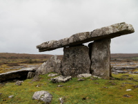
Poulnabrone Dolmen
West Ireland | County Clare
Poulnabrone is a classic example of a portal tomb and probably one of the most famous megaliths in Ireland. It is situated on the Burren's limestone pavement just beside road R480 (more or less in half way between Ballyvaughan and Leamaneh). Monument stands in a low circular mound of loose stones, measuring about 10m in diameter. The entrance to a rectangula... more info and photos
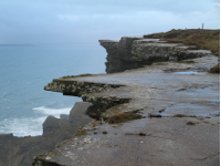
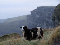
The Cliffs of Moher
West Ireland | County Clare
Cliffs of Moher are Ireland's greatest natural attraction visited by about a million tourists a year. The Cliffs rise to 214m (700 feet) at the highest point and range for 8km (5 miles) over the Atlantic Ocean on the western seaboard of Co. Clare. The name "Cliffs of Moher" derives from an ancient fort "Mothar", which was located in the place where today s... more info and photos