


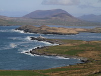
County Kerry
County Kerry (the fifth-largest county) is situated in the south-west of Ireland and is one of the most visited regions of the country. Southern part of the county Kerry consists of three mountainous peninsulas of Beara, Iveragh and Dingle. The northern part is a undulating plain stretching to the Shannon Bay. Beara Peninsula - only a small, north-western part, belongs to the county Kerry, the rest of the peninsula belongs to the county Cork. It's mountainous peninsula with jagged, rocky, coastline typical for west county Cork region. The scenic "Ring of Beara" (almost 200 km long circular tourist route for cars) which starts in Kenmare gives great views around peninsula. For hiking enthusiasts, there is The Beara Way - long distance waymarked trail (206 km or 128 mile), with a large concentration of historical and archaeological sites. Iveragh Peninsula contains highest mountain range (MacGillycuddy's Reeks) which includes 9 of 10 the highest peaks of Ireland (Carrauntoohil is the highest one - it's 1,038 metres or 3,406 ft). A great way to explore the Iveragh Peninsula, is to follow The Kerry Way, one of the longest (214 km) and also one of the most popular marked hiking trails in Ireland. An alternative way to explore peninsula is to drive through the Ring of Kerry, which is a almost 180 km long, circular tourist route. Both, the Kerry Way and the Ring of Kerry begins and ends in the town of Killarney , which is very popular travel destination and offers accomodation, great food and local folk music. The main reason why so many tourists visit Killarney is undoubtedly the surrounding landscape. There are three beautiful lakes (Lough Leane - Lower Lake, Muckross Lake - Middle Lake and Upper Lake), a huge and wonderful Killarney National Park and Torc Mountain with famous Torc Waterfall (18m high). Approximately 17 km from town of Killarney in Kenmare direction (road N71) there is viewing point called "Ladie's View" from where you can enjoy the stunning views of Upper Lake, Gap of Dunloe and Black Valley. There are also a few notable historic sites within the town of Killarney like Ross Castle, Muckross Abbey and Muckross House (19th century mansion house) with magnificent Muckross Gardens. There are also a few interesting historic buildings scattered across Iveragh Peninsula like Staigue Fort, Cahergall Stone Fort, Leacanabuaile Stone Fort or Ballycarbery Castle. Not so far from the western end of the peninsula are situated very popular islands: Skellig Islands (renowned for its scenery, sea bird colonies, long-lived lighthouse service and Early Christian Monastery - recorded in UNESCO) and Valentia Island which is connected with the land by the bridge. The Dingle Peninsula has something to offer to everyone: mountains with second highest peak in Ireland (Mount Brandon - 952 m or 3123 ft); sandy beaches like Inch Beach, Fahamore Beach and Ventry Beach; high concentration of ancient sites (Dunbeg Promontory Fort, Gallarus Oratory, Fahan - collection of drystone beehive huts). Visiting Dingle Peninsula don't miss the Connor Pass - the highest mountain pass and also one of the most scenic roads in Ireland, especially popular among cyclists. To the west of Slea Head is situated Blasket Islands Archipelago which is popular travell destination for wildlife enthusiasts.
Interesting places in county Kerry
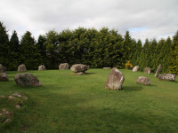
Kenmare Stone Circle
Southwest Ireland | County Kerry
Kenmare Stone Circle, locally known as Shrubberies, is located just a few minutes walk from the center of Kenmare Town in County Kerry. It is considered to be the largest stone circle in the southwest of Ireland. It has an oval shape of a diameter of 17m at the widest point and 15m at the narrowest. It consists of 15 large stones with a large boulder burial ... more info and photos
Shronebirrane Stone Circle
Southwest Ireland | County Kerry
Shronebirrane Stone Circle is located in the valley of the Drimminboy River, about 4km southeast from Lauragh, on Beara Peninsula, in County Kerry. This recumbent multiple-stone circle has a diameter of 7,5 meters and had 13 stones of which 8 remained. The tallest, north-east portal stone dominates the ring and is about 2.6 meters. The height of the stones d... more info and photos
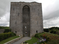
Listowel Castle
Southwest Ireland | County Kerry
Listowel Castle is a tower house located in the town of Listowel, about 25 km northeast from Tralee in County Kerry. It was probably built in the15th century by Fitzmaurice family (Lords of Kerry), on the site of an earlier castle believed to be from the 13th century. The castle stands on the banks of river Feale, above the location of a strategic ford. Orig... more info and photos
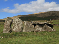
Coom Wedge Tomb
Southwest Ireland | County Kerry
Coom Wedge Tomb is situated just of the scenic road Skellig Ring, about 3 km east of Ballinskelligs, on Iveragh Peninsula in County Kerry. It dates from the time between the late Stone Age and the early Bronze Age. Excavations were carried out in 1965-66 and only a short flint flake was found under the remains of the cairn. No traces of burials or grave good... more info and photos
Reask Monastic Site
Southwest Ireland | County Kerry
Reask are ruins of the early monastic settlement located about 1 km east of Ballyferriter village on the west end of Dingle Peninsula, County Kerry. This is a very interesting example of the early medieval ecclesiastical site, dating back to about the 6th century. The ruins of Reask were revealed during the excavations carried out by archaeologist Tom Fannin... more info and photos
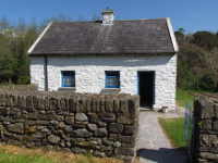
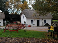
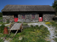
Molly Gallivan's Cottage
Southwest Ireland | County Kerry
The Molly Gallivan's Cottage and Traditional Farm is small open air museum located in Releigh near Bonane, on Beara Peninsula (Co Kerry), just off the road N71, in the middle way between Kenmare and Glengarriff. The cottage and farm depicts the everyday life in rural Ireland over 200 years ago, before the times of elecrticity and modern conveniences. Molly w... more info and photos
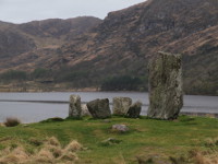
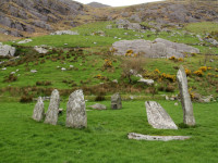
Uragh Stone Circle
Southwest Ireland | County Kerry
Uragh Stone Circle is located near Gleninchaquin Park, on Beara Peninsula, County Kerry (around 15km southwest from Kenmare, signposted on the road R571). It has stunning location on the low hill between lakes Cloonee Upper and Lough Inchiquinn, with the waterfall on the background. The stone circle is 2.4 m (8 feet) in diameter and consists of five upright... more info and photos
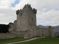
Ross Castle
Southwest Ireland | County Kerry
Ross Castle is situated on the shore of Lough Leane, in Killarney Town, County Kerry. The exact date of construction is uncertain but probably was built in late 15th century by O'Donoghue Mór chieftains, who had undisputed hold over Killarney area at that time. In 1580's after Second Desmond Rebellion, Ross Castle passed into the hands of Donal MacCarthy, bu... more info and photos
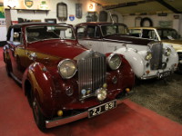
Kilgarvan Motor Museum
Southwest Ireland | County Kerry
Kilgarvan Motor Museum is located just 5min drive to the south from Kilgarvan Town in County Kerry. The museum is run by Mitchells family (John, his wife Joan and two sons) who are collecting and restoring old cars since 1970's. There is huge collection of classic cars, beginning from the very old ones as 1926 Ford model T, throughout very unusual like 195... more info and photos
Muckross Traditional Farms
Southwest Ireland | County Kerry
Muckross Traditional Farms are open air museum situated in the heart of Killarney National Park on the grounds of famous Muckross House and Gardens. There are examples of three working farms of different sizes: Kissane's small farm, Foley's midium size farm and Quille's large farm. In addition to the farms, you will also find there O'Connors labourer's cotta... more info and photos
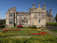
Muckross House and Gardens
Southwest Ireland | County Kerry
Muckross House is a one of the most famous and most visited Victorian mansions in Ireland. The estate is situated in the heart of Killarney National Park on the eastern shore of Muckross Lake. The house was built by Herbert family and designed by famous Scottish architect, William Burn. The most of the garden dates back to the 1850s and was laid out by the f... more info and photos
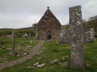
Killemlagh Church
Southwest Ireland | County Kerry
Killemlagh Church (Cill Imleach) is a ruin of an Irish Romanesque church dating from 12th century. Is said to have been built on the place of early Christian monastery founded by St Finian. In 19th century the new chapel was attached to already ruined medieval church. Killemlagh is situated on picturesque Skellig Ring Drive between the villages of Portmagee ... more info and photos
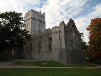
Muckross Friary
Southwest Ireland | County Kerry
Muckross Friary is located in Killarney National Park just about 1.5km from Muckross House and Gardens (about 4,5 km south of Killarney, just off the road N71). It was founded by Donal MacCarthy Mór in 1448 for Observantine Franciscans. After the Dissolution of the Monasteries in the 1540s friary was officialy suspended but friars stayed there until they wer... more info and photos
Kerry Bog Village
Southwest Ireland | County Kerry
Kerry Bog Village is an open air museum which gives people an insight into how people lived and worked in Ireland in the 18th and 19th centuries. It is located on popular Ring of Kerry between Killorglin and Glenbeigh (road N70), just beside the Red Fox Inn. The replicas of the dwellings are very carefully prepared with strong attention to details and equipp... more info and photos
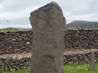
Kildreelig Early Christian Site
Southwest Ireland | County Kerry
Kildreelig Early Christian Site is located in southeastern part of Bolus Head, 4.5km southwest from Ballinskelligs (just 1km further than Kilrelig Artist Retreat Village), in County Kerry. The remains of this early Christian settlement dates from 8th century and contains ruins of oratory and huts, souterrain and part of enclosing wall, but the most remarkab... more info and photos
Loher Stone Fort
Southwest Ireland | County Kerry
Loher Stone Fort is situated on the foothills of Beenarourke and Farraniaragh Mountain, overlooking Ballinskelligs Bay, midway between towns of Caherdaniel and Waterville, on the Iveragh Peninsula in County Kerry (visible on the "Ring of Kerry" scenic coastal road). This drystone walled ring fort, which was really a defensive farmstead of local chieftain, w... more info and photos
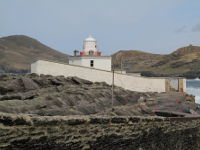
Valentia Lighthouse
Southwest Ireland | County Kerry
The Valentia Lighthouse is located within Cromwell Fleetwood Fort from 17th century (decommissioned in 1669). It was established at the initiative of the Right Honorary Maurice Fitzgerald, Knight of Kerry, and designed by George Halpin Senior, one of the most famous civil engineers of the time. The first light flashed here on 1st of February 1841 and until t... more info and photos
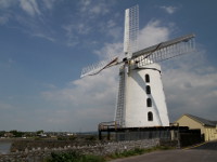
Blennerville Windmill
Southwest Ireland | County Kerry
Blennerville Windmill is located on the periphery of Tralee Town in County Kerry, just off the road N86 leading to Dingle. The mill was established by Sir Rowland Blennerhassett in 1800 and was used to grind corn for local needs as well as for export to Britain. Milling at Blennerville was continued until 1850, then the windmill began to fall into decline a... more info and photos
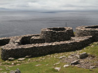
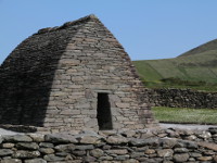
Caher Conor
Southwest Ireland | County Kerry
Caher Conor (Cathair na gConchuireach, also known as the Fahan Beehive Huts) is located on the southern slope of Mount Eagle, to the west of Ventry, on Dingle Peninsula, County Kerry (road R599, not far from Dunbeg Promontory Fort). This enclosed farmstead contains five clochans (beehive huts) within its walls and was probably inhabited by single family. Su... more info and photos
Carrigafoyle Castle
Southwest Ireland | County Kerry
Carrigafoyle Castle is a 15th century fortress situated on southern bank of Shannon estuary, near village of Ballylongford in north County Kerry. This large, five storey tower-house stands on rock in Shannon River and is surrounded by double defensive walls with moat inside and outside, was built in the 1490s by O'Connors of Kerry, very powerful irish cl... more info and photos
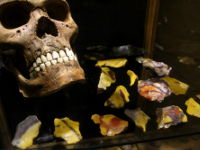
Celtic and Prehistoric Museum
Southwest Ireland | County Kerry
The Celtic and Prehistoric Museum is located beside the road R559, in Klvicadowing near Ventry (west of Dingle Town) on the Dingle Peninsula. This small, well furnished museum offers a large collection of artefacts from all over Europe, dating from 500 million years ago until the middle ages. The biggest attraction is undoubtedly the large complete Wooly Mam... more info and photos
Kilmalkedar Church
Southwest Ireland | County Kerry
Kilmalkedar Church (Cill Maolcheadair) is located 8 km to the northwest of the town of Dingle (road R559), on the Dingle Peninsula in County Kerry. This twelve-century Romanesque church was built on the site of an early-Christian monastic settlement from the 7th century, founded by St. Malkedar - grandson of the King of Ulster. The church consists of the nav... more info and photos
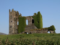
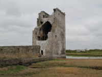
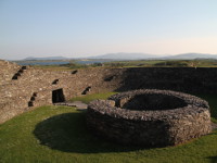
Ballycarbery Castle
Southwest Ireland | County Kerry
Ballycarbery Castle is a ruin located near Cahersiveen in Ballycarbery East on Iveragh Peninsula in County Kerry. It was built in16th century by McCarthy Mor, one of Ireland's greatest medieval dynasties. In 1652 Oliver Cromwell's troops severely damaged the castle using the cannons and fell into decay. In the 18th century the house was built and inhabited o... more info and photos
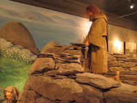
The Skellig Experience Visitor Centre
Southwest Ireland | County Kerry
The Skellig Experience Visitor Centre is located on Valentia Island in County Kerry, right by the bridge which connects the island with the mainland, opposite the fishing village of Portmagee (just 11 km [7 miles] off the Ring of Kerry, between Cahersiveen and Waterville). The whole exhibition is dedicated to The Skellig Islands, and with its video, graphic... more info and photos
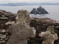
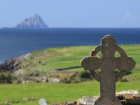
Skellig Islands
Southwest Ireland | County Kerry
The Skellig Islands (Irish: Na Scealaga) are two small, rocky islands : Great Skellig (also known as Skellig Michael) and Little Skellig. Islands are located about 12 km off the coast of Portmagee on the Iveragh Peninsula in County Kerry. The Skellig Micheal is renowned for its Early Christian Monastic Settlement (designated as a UNESCO World Heritage Site... more info and photos
Slea Head Famine Cottages
Southwest Ireland | County Kerry
Slea Head Famine Cottages located on Dingle Peninsula in county Kerry are a memorial reminding the tragedy of Great Famine (Irish: an Gorta Mór) from the mid 19th century. The result of this tragedy was the death of a million people and the emigration of another million, reducing the Irish population by about 25%. The cottages are made up of main farmers co... more info and photos
Gallarus Oratory
Southwest Ireland | County Kerry
Gallarus Oratory (Irish: Séipéilín Ghallarais, what means "The Church of the Place of the Foreigners") located on the Dingle Peninsula, County Kerry, it is probably early Christian church. Is believed to have been built between the 6th century and 9th century. There is no clear evidence when and by whom was built but one is sure, it was built with perfect pr... more info and photos
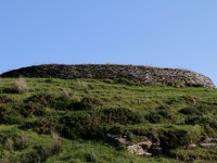
Staigue Fort
Southwest Ireland | County Kerry
Staigue Fort (An Stéig) is partly ruined (but one of the largest and finest in Ireland) dry-stone, walled ringfort, located on the Iveragh peninsula in County Kerry (Ring of Kerry). Probably built in the early centuries AD as defensive stronghold for local chieftain. Fort is surrounded by earthen bank and ditch, has about 27 m (90 ft) in diameter, its wa... more info and photos
Dunbeg Promontory Fort
Southwest Ireland | County Kerry
Dunbeg Fort (Dún Beag) is located on craggy promontory between Ventry and Slea Head (road R599) on Dingle Peninsula in County Kerry. Remains that have survived to this days were built between the 8th and 10th century, but excavations have shown some evidence of human residence dating from 8th century BC. There is no evidence that Dunbeg was ever again occu... more info and photos
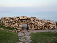
Leacanabuaile Stone Fort
Southwest Ireland | County Kerry
Leacanabuaile Stone Fort is located near Cahersiveen in Ballycarbery East on Iveragh Peninsula in County Kerry. Partly reconstructed but still under construction dry-stone walled fort is one of very few in Ireland of these to be excavated (in 1939/40). Objects found there dating from 8th and 9th century and suggesting the existence of an early Christian f... more info and photos
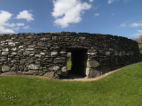
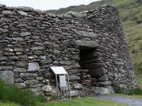
Cahergall Stone Fort
Southwest Ireland | County Kerry
Cahergall Stone Fort is located near Cahersiveen in Ballycarbery East on Iveragh Peninsula in County Kerry. The name Cahergall comes from the Gaelic words, Chathair Gheal, which mean “The Bright Fort”. Recently renovated dry-stone walled ring fort probably dates from late Iron Age or early Medival period. It has about 25 meters in diameter, walls are up to 4... more info and photos
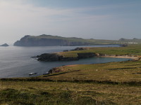
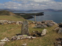
Valentia Island
Southwest Ireland | County Kerry
Valentia Island, is one of Ireland's most westerly points, lying off the Iveragh Peninsula in the southwest County Kerry. The island is linked to the mainland by bridge at Portmagee and by car ferry departing from Renard Point (5km from Cahersiveen) to the village of Knightstown. The island stands out abundant wildlife supported by the warm Gulf Stream and o... more info and photos